Railway for Dovenby Hall
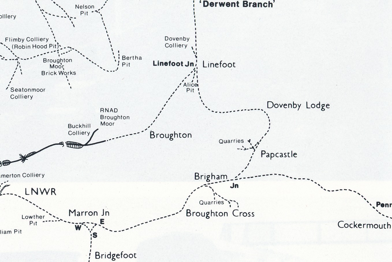
The Derwent branch with the private halt at Dovenby Hall
Dovenby Hall had its own private railway station, complete with its own Dovenby station house and a house for the attendant manning the level crossing over the minor road between Dovenby Craggs and Broughton. The Dovenby loop branched from the Workington to Cockermouth railway which ran along the south of the River Derwent, now the A66 where, at the junction to Brigham the railway crossed north over the River Derwent. Until the floods of 2009 travellers on the A66 could see the bridge wall made of chiselled sandstone on the banks of the Derwent opposite Brigham that once supported the bridge of the railway to Dovenby and beyond. (nb at the turning to Brigham the church on the right has a fortified Pele Tower – see link to reivers.info)
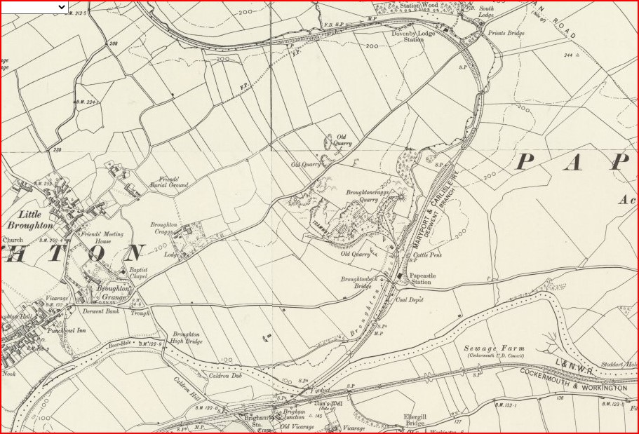
The 1947 OS map shows the route from Brigham over the River Derwent [Google maps 54.667056, -3.415874 ] It then followed the gentle slope of Broughton Beck with a request stop for Papcastle [Google maps 54.670694, -3.411066] where the station buildings remains. The rail track continued to the private station for the Ballantyne Dykes at Dovenby Hall [Google maps 54.679364, -3.408205] The track looped to Dovenby where it crossed the minor road between Dovenby Craggs and Great Broughton and crosses Brides Beck. [Google maps 54.679563, -3.406072]
The 1947 OS map does not show the Dovenby station house where presumably there was a platform, nor does the 1947 OS map show the location of the Papcastle platform though Google maps shows the fine homes of the station master.
The rail line then leaves Dovenby Hall station and follows the slight slope of Carr Beck due west and the obvious remains of the track bed are now seen in the lovely path from Dovenby, to the sewerage works, cross the beck, over the stile to the field and keep right along its perimeter to drop to the gate and bridge across Carr Beck, turn right and see the old track bed that is now a farm track between fields. Although the official path to go up the bank on the left then diagonally over a field, if you stay on the old rail track it brings you to where open cast coal mining reshaped the land.
The old Dovenby rail route was the Maryport & Carlisle Railway (M&C) and then bends to the north and runs parallel to the London, Midland & Scottish Railway (LM&SR) railway line. Yes, two rival railways running beside Dovenby! See links and maps. These two railway lines run parallel to each other and crossed at the end of the old Roman Road from Dovenby. In fact, at the end of the lovely lane going north from Dovenby where it ends at the road to Broughton, that road is built on the foundations on the route of the old LM&SR railway line going westward until the road bends into Great Broughton. West of Great Broughton the old railway line continues to be used, though in its modern form it is a beautiful cycle track, part of a network that follow the route and bed of the old railways in the area. Well done to the visionaries who resurrected and redefined local transport from puffing steam trains to puffing cyclists!
Back on the rail line from Dovenby, with its rival rail line running parallel and both racing to the north they both cross the A594 at that pair of junctions to the left – to Great Broughton and to Broughton Moor. Have you noticed the odd old road layby on the right, where there had been a long term temporary traveller encampment but is now a plantation? That was where the railway crossed. Next time you go left, north, from Dovenby and see the road to the right at Tollbar Cottage (see explanation later) that goes to the east side of Dearham, notice just before entering Dearham there is a row of terrace houses above the road on the left and the old bridge parapets on the road (the road floods here), this is Dovenby Close where both railway lines meet. And when you leave Dearham going east towards Gilgrux you go over the old railway bridge. And if you carry on – at this point use Google maps, click the terrain layer and see the green grass and note the brownish line from Dearham going diagonally northwards.
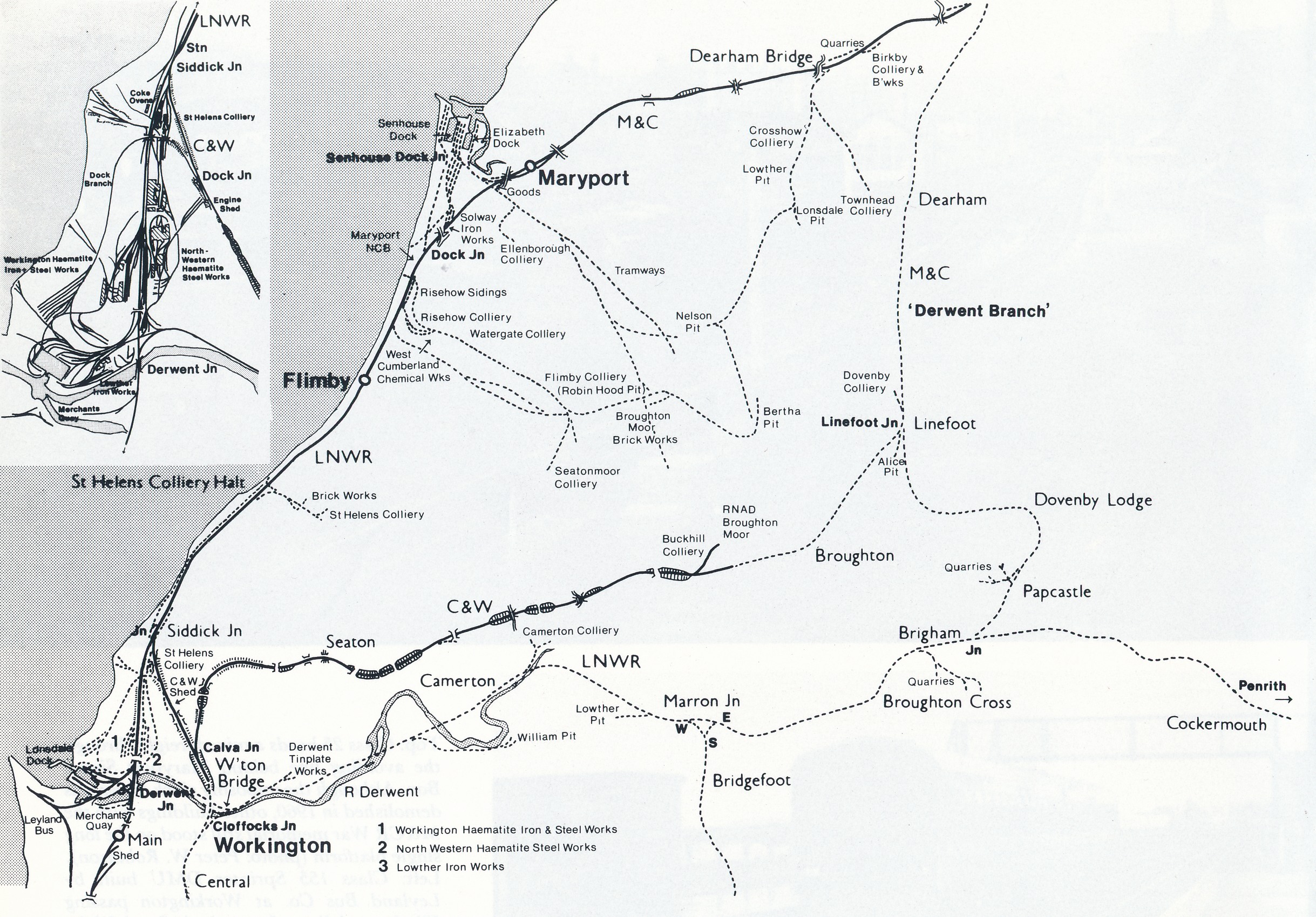
For an adventure, if you leave Dearham, going towards Gilcrux you are on Row Brow and if you pass the farm on the left, pass the new house, past the beck on the left, see a lane a bit overgrown on the left, park there at [Google maps 54.717868, -3.402097 ] and walk up the lane to Rose Gill and fight your way on, then I remember seeing the remains of an old railway bridge there, [Google maps 54.726088, -3.418965] and you see the line of the old railway left and right. It may be the case that you can find the path continues to the “pyramid” slag heap that you often see in the distance. Please ask permission from someone. With imagination, and help from Google satellite view, you can see the old railway line continuing to Bulgill where it joins the main railway line, six miles north from the junction at Brigham.
For more information see
Dovenby Lodge railway station Wikipedia
Disused Railways.org an excellent record with detailed information and photos, please upload your own photos to its moderator click for disused railways
Papcastle Parish website click for local railway routes, thanks to the researcher and publisher
Cumbrian Railway Association a comprehensive organisation with website information of history and current activities click for cumbrian railways
Coal and Railways
To appreciate the significance of the amount of coal mining that justified much of the use of the railway in the area see links to the Coal Authority in this area.
To appreciate the amount of coal resources that were eventually mined by surface opencast in this area, and to appreciate the excellent restoration of the surface after the coal was extracted, visit Soddy Gap ponds nature area and see the links below.
The Ballantyne Dykes of Dovenby Hall may have had rights and ownership of land for mining that caused them to have the railway line built with a loop to their home at Dovenby Hall. Railway travel was a more convenient and comfortable transport in the days before tarmac roads and internal combustion engine powered road transport. The alternative to rail travel might have been a bumpy ride on a slow horse drawn carriage. Dovenby station was a private station built for the sole use of the Dykes family of Dovenby Hall, one of whom was the chairman of the M&C in the 1840s. The first car was Benz in 1886, the model T was 1908.
Cockermouth railway to Keswick and Workington
The main railway ran from Workington to Cockermouth and its remains can still be seen in Cockermouth where the track has been made into a footpath that goes from behind Aldi, crossing Sullart Street then past the old fire station to continue over the high bridge over the River Cocker. The line then ran towards Bassenthwaite where the old Bassenthwaite Station buildings are the location of a replica locomotive and carriages (originally the setting for Murder on the Orient Express film).
The rail line continued to Keswick where Keswick station is now part of the Keswick Hotel, and the line continues to Threlkeld, a lovely walk over a rail route that spans the River Greta a number of times.
Nearby at Threlkeld Quarry Mining Museum the narrow gauge railway has steam and diesel locos hauling tourists around the old quarry with a heritage and mineral museum and collection of working rope excavators.
The Derwent branch with the private halt at Dovenby Hall
The following is from “Rails round the Cumbrian Coast” by Richard Kirkman and Peter van Zeller Page 23 ISBN 0 85206 938 3 Dalesman Books 1988
This 6-mile branch linked the M&C [Maryport & Carlisle railway p3] , main line at Bullgill to the Workington-Cockermouth line at Brigham. Although shorter than the Mealsgate loop, it had more significance as a through route for both passengers and freight. This stemmed from an agreement made with the LNWR [London and North Western Railways p4] in 1866 whereby half the iron ore sent from the WC&E system to Scotland would use the branch, making it in effect an extension of the Moor Row to Marron Junction line.
Later the C&WJ’s [Cleator & Workington Junction Railway p4] Northern Extension added traffic from that system, while for fifteen years passengers could travel between Keswick and Carlisle using the branch. The line was authorised in 1865 and was quickly built, opening to goods traffic in April 1867 and for passengers two months later.
Branch platforms were added at Bullgill and Brigham at each end of the line and intermediate stations at Dearham, Dovenby and Papcastle. The latter was at least in later years a ‘signal stop’, passengers wishing to join the train there had to alert a platelayer’s wife living nearby who would set the signal for the train to stop.
Dovenby was a private station throughout its existence, built for the sole use of the Dykes family of Dovenby Hall, one of whom was the chairman of the M&C in the 1840s (it is reckoned that the M&C had two of the eight British stations to remain in private ownership).
In 1922, the line had five to six weekday passenger trains each way, some linking Maryport and Cockermouth, despite the need for reversals at both Bullgill and Brigham. However, two were Carlisle-Keswick trains, introduced by the M&C in 1920; this service was continued by the LMS with through carriages up to the closure of the branch.
A short-lived addition to the passenger facilities was at Unefoot, where the line from Calva Junction had joined the branch in 1887, but this station was only in use for services on the C&WJ for two months in 1908.
The end of through services by that company (along with the closure of the Solway Viaduct) in 1921 marked the end of the line’s importance for freight, and it is surprising that the passenger and local goods services lasted until 1935.
Once closed on 29th April the line was soon lifted, leading to a tragic accident on 16th December 1936 when the girder bridge over the Derwent near Brigham collapsed during demolition, killing two men. Little is left at the northern end of the branch but further south both Papcastle station buildings and the private station at Dovenby survive, and two remaining piers of the bridge over the Derwent can be seen from the A66.
[These bridge piers were swept away in the floods of 2009 ? ]
Text with my own additional notes From Rails round the Cumbrian Coast by Richard Kirkman and Peter van Zeller Page 23 ISBN 0 85206 938 3 Dalesman Books 1988
For more read the book “Lost Railways of Cumbria by Gordon Suggitt, Countryside Books 3 Catherine Road Newbury Berkshire ISBN 978 1 84674 107 4 published through mrm Assooc Ltd Reading